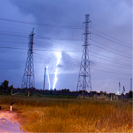
Located on Mississippi’s Gulf coast, Coast Electric Power Association provides electricity to Harrison, Hancock and Pearl River counties, in a region infamously known as “Thunderstorm Alley.” According to a report by Live Science, the area averages 18.0 lightning strikes per square mile, 856,384 strikes per year, and ranks as the 14th deadliest state for lighting strikes. According to the National Weather Service, there have been three lightning strike fatalities in Mississippi in 2016 and an average of 10 per year since 2006.
“We love our gulf breeze,” said Jeremy Bond, Coast Electric’s Senior System Engineer, “but we pay for it.”
Coast Electric’s GIS supervisor, Jay Santinelli, said the inland clash of humidity with water temperature is the perfect recipe for thunderstorms and lightning. From 2014 to 2016, Thunderstorm Alley saw even more lightning strikes and severe weather, causing the number of power outages to skyrocket and leaving Coast Electric with a large amount of work.
Coast Electric first saw a huge surge in maintenance issues and power outages for residents along the Mississippi coast following Hurricane Katrina in 2005. From 2005 to 2016, Coast’s business and their service area grew to encompass a wide variety of terrain. Bond said the co-op’s footprint now consists of a lot of rural areas and a growing number of urban areas, too, including the cities of Biloxi and Bay St. Louis.
The increasingly high likelihood of storm outages in the region combined with the growing number of members they serve presented a double challenge to Coast. The co-op needed a solution to help workers communicate with each other quickly and efficiently to fix outages and to navigate service areas safely.
“Using AVL combined with OMS makes the decision-making process simpler and quicker because it’s visual for us,” said Santinelli.
